
"There are no more Ramin trees here; they were all cut down during the logging concession (HPH) era. Even the seedlings are gone—they don't grow anymore."
November 17, 2025: The journey to monitor the presence of Ramin began. Uan (51, pseudonym), a senior forest monitor with extensive experience in Central Kalimantan, led the expedition. “Today, we will start our monitoring in Katingan Regency for two days, followed by one day in Pulang Pisau and three days in Kapuas,” he briefly explained. Ami (pseudonym) and I hurried to prepare our gear—cameras, GPS, a change of clothes, machetes, and other essentials. We didn't want to waste the first day waiting for the sun to rise higher; we wanted to reach the monitoring points immediately, determined not to miss a moment given how quickly the weather can change.
These three regencies were randomly selected from a list of 10 areas identified as potential Ramin habitats by an Ecological Niche Method (ENM) study. Those ten areas include the regencies of Katingan, East Kotawaringin, West Kotawaringin, Sukamara, Pulang Pisau, Kapuas, Seruyan, South Barito, East Barito, and the city of Palangka Raya. Although Pulang Pisau was not part of the initial plan, we decided to survey it to expand our reach and gain a broader perspective on the monitoring area.
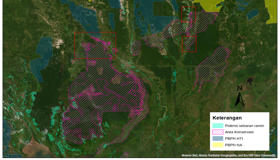
Figure 1. A map showing the potential presence of Ramin in Central Kalimantan, based on Ecological Niche Method (ENM) analysis.
Monitoring the presence of Ramin in its natural habitat is essential today, considering its status as a “Critically Endangered” species based on the 2018 IUCN report and its inclusion in the CITES Appendix II list in 2004. However, to this day, based on CITES data (accessed 06/25/2025) for the 2020-2023 period, the export and import of Ramin wood continues to occur in the market in the form of wood products, processed wood, round logs, sawn timber, wood logs, dried plants, and wood chips/scraps. The data presented shows 37,442 specimens, 3,788.4 m3, and 140,600 kg of traded wood. The critical situation occurring in this tree's habitat is becoming increasingly dire every day, even though it has been internationally listed as a plant whose trade must be strictly guarded. The exploitation of this species has not been followed by cultivation or management efforts to preserve Ramin (Bob and Parno, 2003), which is essentially a plant characterized by slow and poor regeneration (Mansur et al., 2024; Wardani et al., 2010). On the other hand, no less importantly, a shifting paradigm in viewing land and commodities has caused massive land clearing in Central Kalimantan, leading to the continuous erosion and endangerment of Ramin habitats.
A Breath of Fresh Air for the Presence of Ramin
In general, while we were at the monitoring sites, the weather conditions changed very rapidly between heat, overcast skies, drizzle, and rain; these four situations alternated continuously, causing the journey to be hindered. Whenever the rain arrived, we could get trapped on the road and could not continue the journey or had to stop the search in the forest due to limited visibility. Rain can flood the roads, which are generally damaged and not easy for vehicles to pass; the entire road was filled with puddles, and peat mud and dusty roads became something we constantly had to endure.
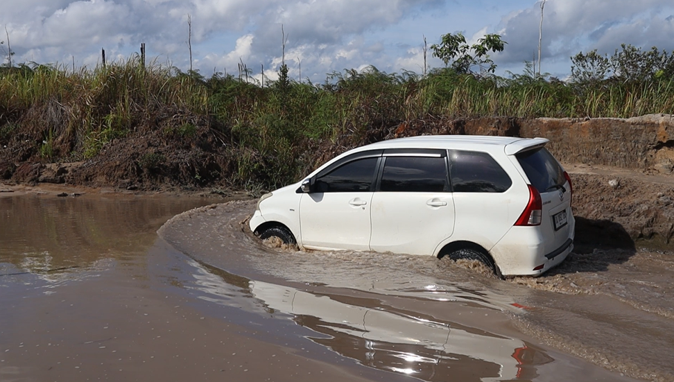
Figure 2. Road conditions during monitoring
Visually, the land conditions along the journey have undergone significant changes into palm oil plantations, rubber plantations, gold mining, sand mining, as well as land fires. This condition was a sight that stretched along the roads, whether on national, regency, sub-district, or village roads in the three regencies we monitored. It is no wonder there is an anecdote saying that Kalimantan in general, and Central Kalimantan in particular, is on the brink of destruction.
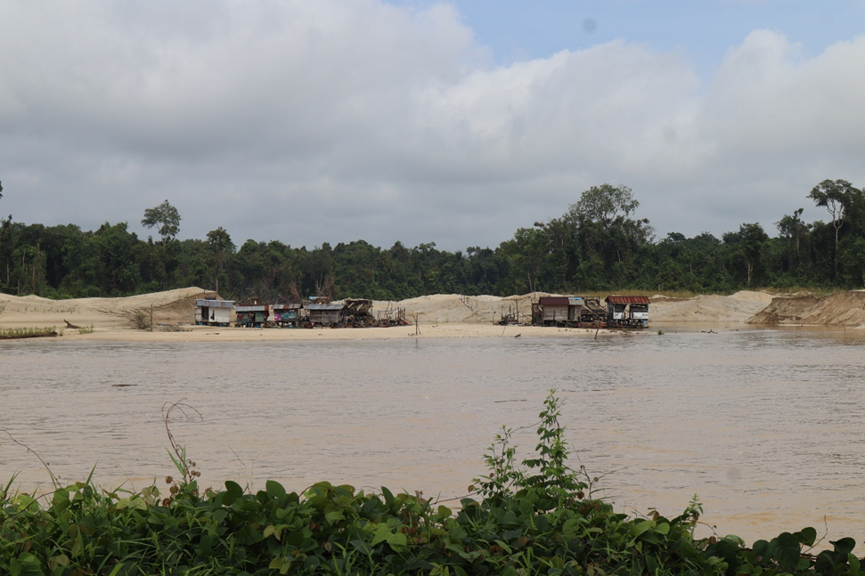
Figure 3. A gold mining site along the monitoring route in Central Kalimantan
When we entered the areas with Ramin stands, a sharp contrast was visible as the forest edges were bordered by the presence of palm oil plantations, both within and outside conservation areas, and belonging to both large-scale palm oil companies and small-scale community-owned farms. These peatlands that dominate Central Kalimantan have become a space for palm oil planting sought after by all parties; the reason being that palm oil has more guaranteed prices, and only palm oil is considered more suitable for planting in such conditions.
Inside the remaining forests where we found Ramin, peat decorated the land. We often found ourselves sinking or stumbling if we were not careful in choosing our footing; this situation was sometimes enjoyable, sometimes annoying, but we kept going with songs of joy. Upon finding Ramin, we realized that forest plants such as Jelutung, Meranti, and pitcher plants always adorned the area surrounding it. Often, if we were not keen at distinguishing them, we thought a Meranti was the Ramin we were looking for, but after approaching the trunk and looking closely, it was not Ramin that we found.
Similarly, we were often deceived by the pneumatophores (breathing roots) of Jelutung, which look like those of Ramin; it requires keen observation to distinguish them, and Uan's experience was vital in this monitoring effort. He slowly explained the differences between Ramin and other species and its distinguishing characteristics. “If you have trouble finding Ramin in the forest, just look at the breathing roots growing to the surface; that indicates Ramin is nearby. But it's different from Jelutung, whose bark is smoother than Ramin's.” Ramin's breathing roots are always located several meters from the trunk, so we only need to scan the surroundings to find the Ramin stands. He added that “these Ramin roots function to stabilize the soil and peat for storing and absorbing water. Therefore, if these plants disappear, the peat is likely to dry out quickly during the dry season, and the potential for flooding during the rainy season increases.”
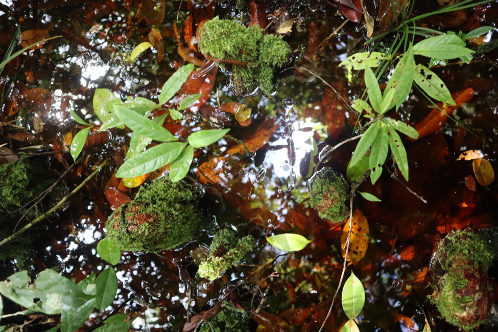
Figure 4. Ramin’s breathing roots emerging to the surface in wet peatlands
Several times we found sun bear footprints in the forest, both claw marks on trees and footprints on the ground. Then, the other most important thing we found was that orangutan nests were always present in the locations where Ramin was found.
Ramin Findings in Katingan Regency
Katingan Regency is one of the regencies located in Central Kalimantan with a dominance of peatlands. The predicted potential growth area for Ramin in Katingan Regency covers 18,945 hectares. This is the largest among the 10 regencies with the potential to have Ramin.
During the journey, the scenery from Palangkaraya to Katingan was filled with appeals not to burn land and forests; these signs indicate that fires in Kalimantan generally occur so frequently that these warnings line the streets. Data from 2001 to 2024 shows that Central Kalimantan lost 900,000 hectares of tree cover due to fires (GFW, 2025). Fundamentally, the dominant peatlands in this area pose a challenge to the sustainability of the peat ecosystem, which is prone to fires and massive land clearing through burning.
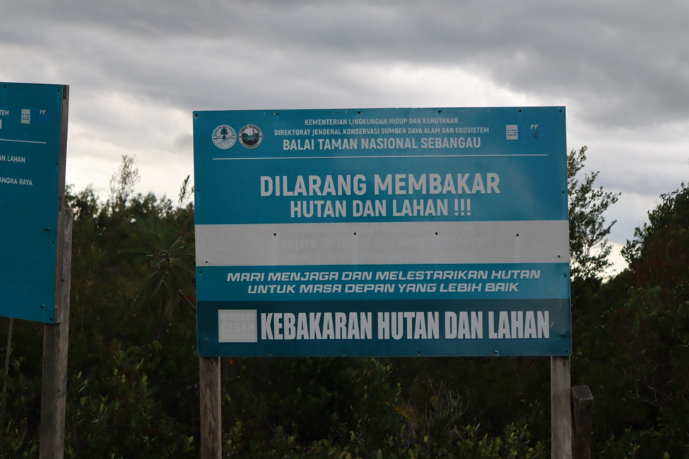
Figure 5. One of the warning signs advising against burning land and forests along the roads of Central Kalimantan.
The three-hour journey to the monitoring site through Handiwung Village, Luwuk Kanan Village, and Tewang Tampang Village—located outside the Sebangau National Park (TN Sebangau) area near Kasongan—was filled with sights of massive land clearing along the route approaching the site. In Handiwung Village, Tasik Payawan Sub-district, Katingan Regency, we found Ramin stands after walking about 1 km along the Hampangen – Mandawai road. This location was dominated by land clearing for palm oil plantations and small-scale gold mines, leaving behind pits filled with water and mud. At this discovery site, natural trees were felled for palm oil land clearing; the logs were still left lying on the ground, and it is unclear whether they will be collected eventually or simply left behind. These fallen trees lay across drainage ditches dug to channel peat water to the river, with the goal of making the land suitable for palm oil planting in the future. The Ramin found here is at risk of disappearing soon, given the rampant land clearing activities in the area.
Essentially, this location presents a different picture compared to the satellite imagery on Google Earth, which still shows significant tree cover (imagery accessed November 17, 2025); in reality, there is already extensive land clearing for mining and plantations.
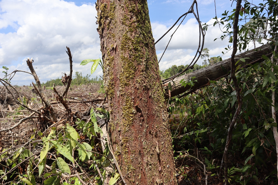
Figure 6. Land clearing for palm oil plantations immediately adjacent to where the Ramin stands were discovered
In another location, we conducted monitoring in the Core Zone of Sebangau National Park. In this area, we only managed to find a single stand with a circumference of 128 cm and an estimated height of 25 meters. This location was reached via Tjilik Riwut Road KM 24, Palangkaraya City, toward the Katingan Regency boundary within the Sebangau National Park area.
The journey involved walking approximately 5 km along the Palangkaraya City Government's drainage road to the administrative border of Katingan Regency and Palangkaraya. The Ramin found within Sebangau National Park was located inside the administrative territory of Katingan Regency after tracking 1 km from the border. Administratively, Sebangau National Park is situated across three regencies/cities: Palangka Raya City, Katingan Regency, and Pulang Pisau Regency in Central Kalimantan Province, covering an area of ± 568,700 hectares. This National Park was officially designated under the Decree of the Minister of Forestry No. SK.423/Kpts-II/2004 dated October 19, 2004.
At this discovery site, we attempted to find other points by exploring the area and tracking the direction in which the Ramin leaned. The lean of the tree usually indicates the presence of other stands. However, this method did not lead us to any new distributions. We suspect that this stand is the sole survivor from past logging activities. This stand remained because it was not yet harvestable at that time. The scarcity of Ramin in Sebangau National Park was confirmed by a plantation worker we accidentally met at the edge of the park, Pak Rino, who said, “There is no more Ramin here; it was all taken during the company era, and there are no seedlings—they don’t grow back.” This conversation was echoed by Uan, who added, “Yes, 40 years ago, this area was completely cleared by HPH (Forest Concession) companies.” Essentially, before becoming a National Park, the Sebangau area was an active HPH concession from the early 1970s until the mid-1990s. Timber transportation was carried out by digging ditches or canals throughout the Sebangau Peat Swamp Forest.
Ramin Findings in Pulang Pisau Regency
Pulang Pisau Regency is one of the 10 potential regencies for Ramin vegetation. It ranks as the 5th largest after Katingan, East Kotawaringin, West Kotawaringin, and Sukamara, with a total growth potential in peat areas covering 6,751 hectares.
One of the existing modes of transportation in this regency is the ferry, which transports passengers across the river from one location to another. To reach our destination, we used the Kahayan River route to cross. During the crossing, we were presented with the sight of active gold mines continuously siphoning gold from the Kahayan River. After crossing and heading to the site, we found Ramin growing in clusters in Manen Paduran Village, Banama Tingang Sub-district, Pulang Pisau Regency. This species coexists with Jelutung and several Orangutan nests. This discovery site directly borders the palm oil plantation of PT Citra Agro Abadi (PT CAA), separated only by a 5-meter-wide plantation road and a river approximately 4 meters wide.
The forest is characterized by peat swamps with varying water depths, where the water often reaches the thighs of an adult. At this location, we ventured further into the forest to record as many Ramin points as possible until we were eventually stopped by the increasing depth of the peat, which made it difficult to navigate deeper into the forest.
In another area still bordering PT CAA, around 1 kilometer from the initial discovery site, we found traces of Ramin timber logging, where the wood had been processed on site into boards measuring 5 cm thick, 20-40 cm wide, and 1 meter long. We estimate that this logging took place 2 to 5 days before our arrival (we arrived at the location on November 19, 2025), as the surface of the wood cuts still looked fresh. We also observed orangutan nests here, further indicating the loss of orangutan habitat in this area.
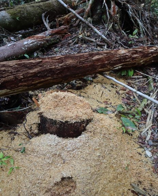
Figure 7. Evidence of Ramin Logging in Pulang Pisau Regency
Ramin Findings in Kapuas Regency
Kapuas Regency is potentially categorized among the five regencies with the lowest Ramin potential (Kapuas, Seruyan, Palangkaraya City, South Barito, and East Barito); however, among these five, Kapuas holds the highest potential with a predicted distribution area of 5,098 hectares. Although Kapuas is potentially smaller compared to the top five potential regions, field evidence shows that this area possesses substantial potential. In this regency, there are two KSA/KPA (Nature Reserve/Nature Conservation Areas) whose management arrangements have not yet been finalized: KSA/KPA Sungai Barito and KSA/KPA Tanjung Malatayur. These two areas are essentially separated only by the Kapuas River, which stretches across Kapuas Regency. Essentially, this location is already heavily populated by communities engaged in various activities, ranging from residential settlements to both small and large-scale economic activities.
In these two areas, we found that based on its distribution points, Ramin is mostly located along roadsides within secondary forests, settlements, palm oil and peatland rubber plantations, gold mines, burned areas, scrubland, fields, and other degraded lands, all of which are dominated by peat. Dilapidated roads are a major characteristic of travel in this region, which results in difficult access for vehicles to reach several monitoring locations. These peat-dominated locations make monitoring increasingly difficult and risky; furthermore, the degraded forest conditions make it hard to find Ramin despite the existing potential. Occasionally, there are access roads into the peat areas, but unfortunately, they often end in dead-ends or daunting peat swamps. It might be possible to enter these forests on foot, but the challenges are immense; according to Avenza Maps measurements, the distance to the target locations can reach 5 kilometers, meaning a full day would be required for the search, not to mention the potential for failure due to unpredictable forest conditions. We found locations with such conditions throughout areas like Lawang Kajang Village (still within the Sungai Barito KSA/KPA), Masaran Village via illegal mining and illegal logging routes, Petak Puti Village, and Humbang Haya Village.
In Petak Puti Village, based on an interview with the Village Secretary, Suharga, Ramin trees were once very abundant in this village around the 1990s. However, due to illegal logging and HPH (Forest Concession) activities from the New Order era until now, Ramin is nearly extinct. The remaining physical presence of Ramin grows within a 4,000-hectare Village Forest permit area. The route to the Village Forest is reached by river for about 1.5 hours, followed by approximately a 1-hour walk. We did not travel to this location even though we had previously planned to visit. The main reason for calling off the expedition here was the unpredictable weather, as there was a clear potential for heavy rain at that time.
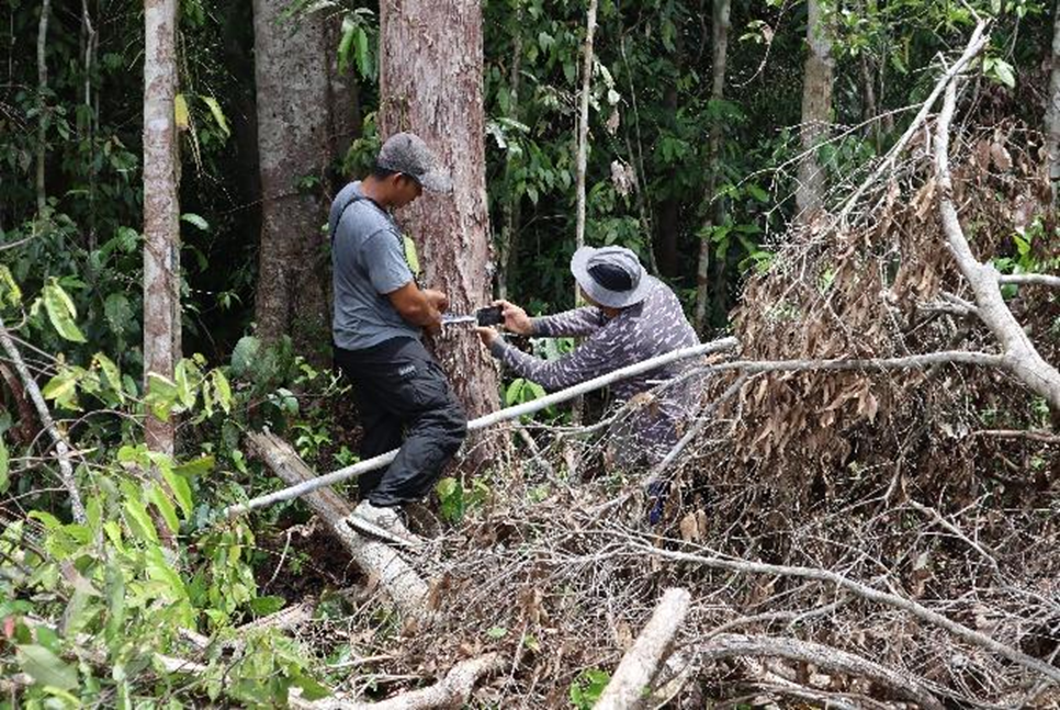
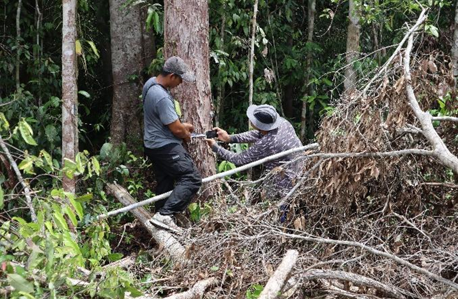
Figure 8. Uan and Ami measure the diameter of ramin trees at the monitoring site.
The Petak Puti Village community realizes that ramin is a rare species and cannot be traded freely as it was 3-4 decades ago. “Currently, the government has prohibited the harvesting of this plant from its habitat,” explained one of the villagers. This statement shows that at the local level, knowledge about the limited existence of this species is sufficient. The challenge lies with hunters who continue to search for these trees to sell internationally.
After leaving this village with interesting stories, we headed to Humbang Raya Village in the Barito River KSA/KPA area. The entrance to the location was greeted by a welcome sign at the 13,075-hectare PT Sakti Mait Jaya Langit palm oil plantation and palm oil mill and an announcement by the Corruption Eradication Commission (KPK) regarding the seizure of all assets at the location. At this location, we found groups of ramin trees of varying sizes. This time, we found ramin saplings with diameters of 1 and 2 cm. Similar to other locations where we found ramin trees, we found several orangutan nests and bear claw marks here. Unfortunately, this location is under real threat due to land clearing for purposes such as the palm oil plantation next to it, which is actually a protected area but continues to be cleared freely.
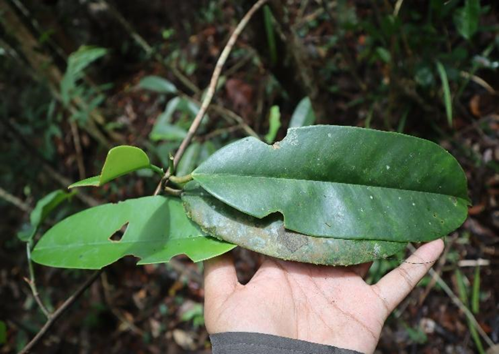
Figure 9. Leaves from ramin seedlings successfully monitored in Kapuas District
Conclusion: The Challenge of Preserving the Ramin Population and Habitat
At this time, we have found that the main challenge to protecting ramin populations and their habitats are:
The conversion of land that was previously forest into oil palm plantations, rubber plantations, gold mines, and new settlements for communities in peat swamp areas. We found that in three districts in the monitored locations, there were oil palm plantations, both smallholder and large corporate plantations, in both conservation and non-conservation areas. For example, in the KSA/KPA Sungai Barito area, there are oil palm plantations and the PT Sakti Mait Jaya Langit palm oil processing factory. This factory is directly adjacent to the ramin location found, separated only by a company road and a drainage ditch to drain peat water. In Handiwung Village, Tasik Payawan Subdistrict, Katingan Regency, a similar threat also comes from oil palm plantations, but the difference lies in the manager, namely the community. The field conditions here are not limited by anything, but are directly located on the same land as the land clearing intended for oil palm plantations.
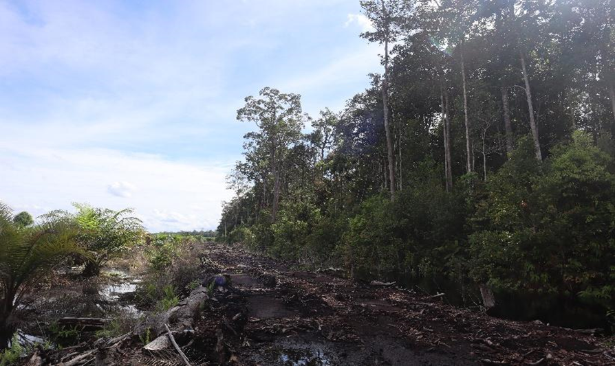
Figure 10. Oil palm plantations are located directly adjacent to the location where ramin was found
Furthermore, the threat of ramin trade, which leads to logging in its natural habitat, is still rampant. Logging activities were found in Pulang Pisau Regency, indicating that the IUCN appendix and red list do not apply to this plant.
As a result of these two factors, the ramin population has declined significantly throughout its range, leaving only fragmented remnant populations (Oldfield et al., 1998). Once more, Pak Rino brief statement, “There are no more ramin trees here,” is relevant when applied to the current situation, namely that ramin trees will disappear from their habitat if land conversion and the ramin trade are not addressed immediately. We must not allow this statement to become a prophecy; we must act quickly.